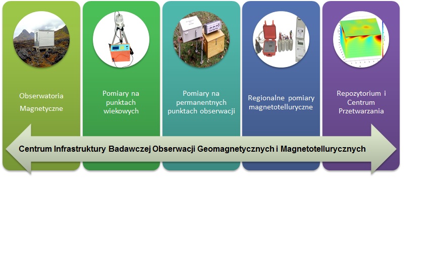
| Geomagnetic and Magnetotelluric Observations Research Infrastructure Center CIBOGM |  |
|
Entity responsible: Institute of Geophysics PAS (IG PAS) Department of Magnetizm |
|
|
Entities implementing: Institute of Geophysics PAS (IG PAS), Institute of Geodesy and Cartography (IGC) |
Infrastructure will be allocated primarily to the implementation of scientific research of a fundamental nature and it may be the basis to apply for funds to conduct such research projects. Conducted geomagnetic observations are a part of a system of European plate observation. They contribute to a comprehensive geosphere tracking, which is important for ecological safety. Data from the Polish magnetic observatories are used in the world very often in scientific studies, or to updated every 5 years global models of the Earth's magnetic field - IGRF and WMM. The station in Hornsund works from approx. 20 years in well-known international IMAGE program, which main objective is to study the currents flowing in the ionosphere in the northern region of "auroral oval".
The results of measurements on the repeat stations are the basis for the development of local models of the magnetic field for the Polish territory at any age. The base is the map of declination and inclination carried out from direct measurements on repeat station network in 1955-1959. The network was reviewed and updated in 2003-2008.
Observations of the Earth's magnetic field are important not only for science, but increasingly also for the economy, especially for the economy of higher and higher level of development. Data from magnetic observatories of Belsk and Hel are the reference level for the national network of repeat stations, on the basis of which magnetic maps of Poland are updated. These maps are important, e.g. for the purpose of air navigation as well as for the defense of the country. Each airport must have updated magnetic declination which is needed to determine the magnetic azimuth of a runway. The infrastructure can be also used for attestation of aircraft compasses, attestation of calibration site for aircraft compasses (Metro-Lab) and measurements of magnetic azimuth airport's runways, performing of magnetotelluric and magnetic measurements for geology, such as measurements of the F vector at designated profiles, magnetic picture, determination of magnetic field parameters at directional-drilling sites.
Continuous tracking of the magnetic field is of fundamental importance in monitoring and predicting of the space weather. The space weather affects the safety of people and the economy. The bad space weather can catastrophically affect the network of power, accuracy and availability of GPS, the functioning of artificial satellites and the quality of satellite communications and radar operation. It is worth noting that for many decades the current registration of changes in the magnetic field is used to forecast the radio communications and the future magnetic activity.
Knowledge of the current declination of the magnetic field is used in directional drilling related to the exploitation of gas deposits. Knowledge of the magnetic field in real time is useful to protect the pipeline from corrosion.
Regional magnetotelluric soundings allow us to draw conclusions about the values of the electrical conductivity of the subsoil. It is an extremely important physical parameter, which allows us to identify geological structures with different petrophysical characteristics.
Electromagnetic methods can detect important zones such as: fault or thrust zones, where porous rocks filled with mineralized fluids, graphite and metal sulfides appear, and the deeper zones of partial melting. They are also an effective tool for exploration of mineral raw materials.
Some products may be used for commercial purposes and the designed infrastructure allows performing service work, such as:
- magnetic measurements,
- magnetotelluric soundings,
- attestation of calibration site for aircraft compasses (Metro-Lab) and measurements of magnetic azimuth airport's runways
- certification of aircraft compasses,
- magnetic measurements in domestic airports in order to determine the magnetic declination at the airport or magnetic azimuth of runway,
- magnetic measurements for geology - measurement of F vector at designated profiles, magnetic picture, determination of magnetic field parameters at directional-drilling sites.
Expertise and interpretation for commercial customers will be able to be carried out using the newly acquired research infrastructure. Also, through the use of the database it will be easier to make expertise and interpretation for commercial customers (particularly environmental data), with especial preference of the project participants.
STRUCTERE